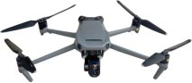
The DT-02 drone has a long transmission distance, long endurance, and strong wind resistance. Equipped with a wide-angle mechanical shutter camera and a high-precision RTK module, it achieves efficient and accurate surveying and mapping; Integrated thermal imaging camera and intelligent AI recognition, it is capable of penetrating thick smoke and automatically locking abnormal heat sources at night. The whole drone is made of high-strength and lightweight materials, and can be folded into a backpack for easy carrying. It is suitable for fire search and rescue, inspection, and night scene operations.
Technical Parameter
|
DT-02 technical parameter
|
|
Unfolded Size
|
347*283*107.7mm
|
|
Folded Size
|
221*96.3*90.3mm
|
|
Net weight
|
915g
|
|
Maximum takeoff weight
|
1915g
|
|
Wheelbase
|
380mm
|
|
Maximum ascent speed
|
6m/s
|
|
Maximum descent speed
|
6m/s
|
|
Maximum level flight speed
|
15m/s
|
|
Maximum wind resistance speed
|
12m/s
|
|
Maximum takeoff altitude
|
6000m
|
|
Maximum flight time
|
39min/55min
|
|
Maximum hover time
|
33min/46min
|
|
Maximum tilt angle
|
30°/35°
|
|
Maximum rotational angular velocity
|
200°/s
|
|
Wide angle sensor
|
1/2.8 ,8 million 290 thousand
|
|
Wide-angle lens
|
63°
|
|
Pixel spacing in thermal imaging
|
12μm
|
|
Thermal imaging resolution
|
256*192
|
|
Thermal imaging lens
|
21°
|
|
Image transmission distance
|
10km
|
|
The above parameters are for reference only. Detailed product parameters are subject to actual delivery.
|
FAQ
Q: Battery replacement time?
A: Hot-swappable batteries change in 20s (no power-down required).
Q: Can it map underground pipes?
A: Optional ground-penetrating radar detects subsurface structures at 3m depth.
Q: Data processing software?
A: Includes DT-SmartView Suite (thermal analysis/3D modeling/PDF reporting).
Q: Training included?
A: Free 8-hour VR simulator access + field certification.

