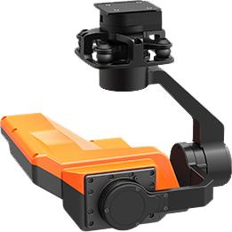
Equipment features
Support connection with unmanned aerial vehicles through a quick release interface
Without disrupting the flow state of water, the flow measurement is accurate, stable, and reliable;
Not affected by silt, sediment, plants, temperature, condensation, etc
FM continuous wave mode has a large bandwidth and high ranging accuracy
High signal-to-noise ratio and strong anti-interference ability
Real time import of cross-sectional information from unmanned aerial vehicle ground station, one click output of flow velocity, water level, instantaneous flow rate
Technical Parameter
|
Technical Parameter
|
|
size
|
210*210*191mm
|
|
weight
|
770g
|
|
Average Power
|
6.0W
|
|
operation temperature
|
-20℃~60℃
|
|
storage temperature
|
-20℃~70℃
|
|
ambient humidity
|
≤ 85% RH (non condensing)
|
|
Two axis stabilization
|
support
|
|
Network video output
|
support
|
|
Enhance stability accuracy
|
±0.01°
|
|
Maximum controllable speed
|
Pitch direction (TILT): ± 200 °/s
|
|
Controllable rotation range
|
Pitch direction (TILT): -50 °~50 °
|
|
resolution
|
720P@25fps
|
|
Water level gauge
|
|
frequency
|
24~26GHz
|
|
beam angle
|
10°
|
|
antenna
|
Planar micro-strip array antenna
|
|
Principle of water level measurement
|
Frequency modulated continuous wave (FMCW)
|
|
Distance measurement range
|
0.25~80m
|
|
Range Accuracy
|
±2mm
|
|
resolution
|
1mm
|
|
Flow meter
|
|
Operating Frequency
|
24GHz
|
|
Speed measurement range
|
0.1~20m/s
|
|
Speed measurement accuracy
|
±0.01m/s,±1%FS
|
|
beam angle
|
12°
|
|
The above parameters are for reference only. Detailed product parameters are subject to actual delivery.
|

